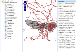
Example サイト
http://www.geoext.org/examples.html
「WMS Capabilities Tree」リンクをクリックすると WMS Capabilities Loader Example が表示されます。
wms-tree.js. を参考にします。
説明を意訳すると、WMS の getCapabilities レスポンスの階層構造を持つツリーを設定するために GeoExt.tree.WMSCapabilitiesLoader を使用する方法を示します。
var tree, mapPanel;

Ext.onReady(function() {

 var root = new Ext.tree.AsyncTreeNode({
  text: 'GeoServer Demo WMS',
  loader: new GeoExt.tree.WMSCapabilitiesLoader({ // WMS のすべてのレイヤーのツリーを作成するローダ。
// url: 'data/wmscap.xml',
   url: './geoserver_wms_gc.xml',
   layerOptions: {buffer: 0, singleTile: true, ratio: 1}, // オブジェクトオプションオプション
   layerParams: {'TRANSPARENT': 'TRUE'}, // オブジェクトオプションパラメータ
   // customize the createNode method to add a checkbox to nodes
   createNode: function(attr) {
    attr.checked = attr.leaf ? false : undefined;
    return GeoExt.tree.WMSCapabilitiesLoader.prototype.createNode.apply(this, [attr]);
   }
  })
 });
 tree = new Ext.tree.TreePanel({
  root: root,
  region: 'west',
  width: 250,
  listeners: {
   // Add layers to the map when ckecked, remove when unchecked.
   // Note that this does not take care of maintaining the layer
   // order on the map.
   'checkchange': function(node, checked) {
    if (checked === true) {
     mapPanel.map.addLayer(node.attributes.layer);
    } else {
     mapPanel.map.removeLayer(node.attributes.layer);
    }
   }
  }
 });
 mapPanel = new GeoExt.MapPanel({
//zoom: 2,
  zoom: 9,
  center: [139.4, 35.7],
  layers: [
/* new OpenLayers.Layer.WMS("Global Imagery",
   "http://maps.opengeo.org/geowebcache/service/wms",
   {layers: "bluemarble"},
   {buffer: 0}
   )
*/
   new OpenLayers.Layer.WMS("Tokyo Gyoseikai mlit WMS",
   "http://192.168.1.6:8080/geoserver/wms?",
   {layers: "sde:gyoseikai"},
   {buffer: 0}
   )

  ],
  region: 'center'
 });
 new Ext.Viewport({
  layout: "fit",
  hideBorders: true,
  items: {
   layout: "border",
   deferredRender: false,
   items: [mapPanel, tree, {
    contentEl: "desc",
    region: "east",
    bodyStyle: {"padding": "5px"},
    collapsible: true,
    collapseMode: "mini",
    split: true,
    width: 200,
    title: "Description"
   }]
  }
 });

});
HTML ファイルを新規作成します。
「openlayersTokyoproj」 を右クリックして 新規 -> HTML ファイル をクリック。
「HTML ファイル」ウィンドウの「ファイル名(任意:geoext14_wms-tree.html)」に入力して「完了」ボタンをクリック。
「charset」を「utf-8」にします。
以下のように HTML を作成します。
geoext13_wms-capabilities.html をコピーし、外部 JavaScript 読み込みファイルを修正し body タグ内に <div id="desc"></div> を設定します。
---
  <title>GeoExt14 WMS Capabilities Tree</title>
---
<!-- wms-tree.js 追加 -->
  <script type="text/javascript" src="./wms-tree.js"></script>

 </head>
 <body>
  <div id="desc">
   <h1 id="title">GeoExt 14 - WMS Capabilities Tree</h1>
   <p id="shortdesc">
    WMS Capabilities Loader Example
   </p>
   <p>This example shows how to use GeoExt.tree.WMSCapabilitiesLoader to populate
    a tree with the hierarchical structure of a WMS GetCapabilities response.
    The example also shows how to customize the loader's createNode method to add
    a checkbox with a checkchange listener that adds and removes layers to and
    from the map.</p>

   <p>この例では、WMS の getCapabilities レスポンスの階層構造を持つツリーを設定するために
    GeoExt.tree.WMSCapabilitiesLoader を使用する方法を示します。また、この例では、
    マップからレイヤーを追加と削除する checkchange リスナーでチェックボックスを追加する
    ローダーの createNode メソッドをカスタマイズする方法を示しています。</p>

  </div>
 </body>
</html>


0 件のコメント:
コメントを投稿