ラベル vector labels の投稿を表示しています。 すべての投稿を表示

2015年10月18日日曜日

OL3-Cesium 7 - ol3cesium vectors example 2

7-2 JavaScript ファイルの作成
「vectors.js(7-ol3cesium18.js)」は、マップを表示するための JavaScript ファイルです。

OL3-Cesium API は、現在、すべて実験的(experimental)なものです。

「7-ol3cesium18.js」
var iconFeature = new ol.Feature({
/** ol.Feature
  * A vector object for geographic features with a geometry 
  * and other attribute properties, similar to the features 
  * in vector file formats like GeoJSON.
  * GeoJSONのようなベクトルファイル形式のフィーチャに類似した、
  * ジオメトリとその他の属性プロパティを持つ地物フィーチャのため
  * のベクトルオブジェクト。(ol3 API)
  */
 geometry: new ol.geom.Point([700000, 200000, 100000]),
 /** ol.geom.Point
  * Point geometry.(ol3 API)
  */
});
var cervinFeature = new ol.Feature({
 geometry: new ol.geom.Point([852541, 5776649])
});
cervinFeature.getGeometry().set('altitudeMode', 'clampToGround');
/** getGeometry()
 * Get the feature's default geometry. A feature may have 
 * any number of named geometries. The "default" geometry 
 * (the one that is rendered by default) is set when 
 * calling ol.Feature#setGeometry.
 * フィーチャのデフォルトのジオメトリを取得します。フィーチャ
 * は、任意の数の指定のジオメトリのを有することができます。 
 * 「デフォルト」のジオメトリ(デフォルトでレンダリングされる
 * もの)が ol.Feature#setGeometry を呼び出すときに設定され
 * ています。(ol3 API)
 */
/** set(key, value)
 * Sets a value.(ol3 API)
 */
var iconStyle = new ol.style.Style({
/** ol.style.Style 
 * Base class for vector feature rendering styles.
 * ベクタフィーチャがスタイルを描画するための基本クラス。
 * (ol3 API[説明は Stable Only のチェックを外すと表示])
 */
 image: new ol.style.Icon(/** @type {olx.style.IconOptions} */ ({
 /** ol.style.Icon 
  * Set icon style for vector features.
  * ベクタフィーチャのアイコンスタイルを設定します。
  * (ol3 API[説明は Stable Only のチェックを外すと表示])
  */
 /** @type 
  * 値のタイプ(型)の説明 - 式などで表示
  * (@use JSDoc[http://usejsdoc.org/]より)
  */
  anchor: [0.5, 46],
  anchorXUnits: 'fraction',
  anchorYUnits: 'pixels',
  opacity: 0.75,
  // src: 'data/icon.png'
  src: './js/libs/ol3-cesium-v1.8/examples/data/icon.png'
 })),
 text: new ol.style.Text({
 /** ol.style.Text
  * Set text style for vector features.
  * ベクタフィーチャの文字列のスタイルを設定します。
  * (ol3 API[説明は Stable Only のチェックを外すと表示])
  */
  text: 'Some text',
  textAlign: 'center',
  textBaseline: 'middle',
  stroke: new ol.style.Stroke({
  /** ol.style.Stroke 
   * Set stroke style for vector features. 
   * Note that the defaults given are the Canvas defaults, 
   * which will be used if option is not defined. 
   * The get functions return whatever was entered 
   * in the options;  they will not return the default.
   * ベクタフィーチャのためのストロークスタイルの設定。
   * デフォルトは、オプションが定義されていない場合に使用され
   * る Canvas のデフォルトを与えられることに注意してください。
   * GET 関数は、オプションで入力されたものはすべて返します。
   * それらはデフォルトを返しません。
   * (ol3 API[説明は Stable Only のチェックを外すと表示])
   */
   color: 'magenta',
   width: 3
  }),
  fill: new ol.style.Fill({
  /** ol.style.Fill 
   * Set fill style for vector features.
   * ベクタフィーチャの塗りつぶしスタイルを設定。(ol3 API)
   */
   color: 'rgba(0, 0, 155, 0.3)'
  })
 })
});
iconFeature.setStyle(iconStyle);
/** setStyle(style)
 * Set the style for the feature. This can be a single style 
 * object, an array of styles, or a function that takes a 
 * resolution and returns an array of styles. If it is null 
 * the feature has no style (a null style).
 * フィーチャのスタイルを設定します。これは、単一のスタイルオブ
 * ジェクト、スタイルの配列、または解像度をとり、スタイルの配列を
 * 返す関数とすることができます。null の場合、フィーチャは、スタ
 * イルなし(null のスタイル)を持ちます。(ol3 API)
 */
cervinFeature.setStyle(iconStyle);
var image = new ol.style.Circle({
/** ol.style.Circle
 * Set circle style for vector features.
 * ベクタフィーチャの円のスタイルを設定。(ol3 API)
 */
 radius: 5,
 fill: null,
 stroke: new ol.style.Stroke({color: 'red', width: 1})
});
var styles = {
 'Point': [new ol.style.Style({
  image: image
 })],
 'LineString': [new ol.style.Style({
  stroke: new ol.style.Stroke({
   color: 'green',
   lineDash: [4],
   width: 1
  })
 })],
 'MultiLineString': [new ol.style.Style({
  stroke: new ol.style.Stroke({
   color: 'green',
   width: 1
  })
 })],
 'MultiPoint': [new ol.style.Style({
  image: image,
  text: new ol.style.Text({
   text: 'MP',
   stroke: new ol.style.Stroke({
    color: 'purple'
   })
  })
 })],
 'MultiPolygon': [new ol.style.Style({
  stroke: new ol.style.Stroke({
   color: 'yellow',
   width: 1
  }),
  fill: new ol.style.Fill({
   color: 'rgba(255, 255, 0, 0.1)'
  })
 })],
 'Polygon': [new ol.style.Style({
  stroke: new ol.style.Stroke({
   color: 'blue',
   lineDash: [4],
   width: 3
  }),
  fill: new ol.style.Fill({
   color: 'rgba(0, 0, 255, 0.1)'
  })
 })],
 'GeometryCollection': [new ol.style.Style({
  stroke: new ol.style.Stroke({
   color: 'magenta',
   width: 2
  }),
  fill: new ol.style.Fill({
   color: 'magenta'
  }),
  image: new ol.style.Circle({
   radius: 10, // pixels
   fill: null,
   stroke: new ol.style.Stroke({
    color: 'magenta'
   })
  })
 })],
 'Circle': [new ol.style.Style({
  stroke: new ol.style.Stroke({
   color: 'red',
   width: 2
  }),
  fill: new ol.style.Fill({
   color: 'rgba(255,0,0,0.2)'
  })
 })]
};
var styleFunction = function(feature, resolution) {
 var geo = feature.getGeometry();
 // always assign a style to prevent feature skipping
 // 常にフィーチャ・スキップを防止するためのスタイルを割り当てま
 // す。
 return geo ? styles[geo.getType()] : styles['Point'];
 /** 条件演算子 condition ? expr1 : expr2 
  * condition: true か false かを評価する条件文です。
  * expr1, expr2: 各々の値の場合に実行する式です。
  * condition が true の場合、演算子は expr1 の値を選択します。
  * そうでない場合は expr2 の値を選択します。
  * (MDN[https://developer.mozilla.org/ja/docs/Web/
  * JavaScript/Guide/Expressions_and_Operators])
  */
 /** getType()
  * Get the type of this geometry. 
  * ジオメトリの型を取得。(ol3 API)
  */
};
var vectorSource = new ol.source.Vector({
/** ol.source.Vector 
 * Provides a source of features for vector layers.
 * ベクタレイヤのフィーチャのソースを提供します。(ol3 API)
 */
 format: new ol.format.GeoJSON(),
 /** ol.format.GeoJSON 
  * Feature format for reading and writing data 
  * in the GeoJSON format.
  * GeoJSON フォーマットのデータを読み書きするための
  * フィーチャフォーマット。(ol3 API)
  */
 // url: 'data/geojson/vector_data.geojson'
 url: './js/libs/ol3-cesium-v1.8/examples/data/geojson/vector_data.geojson'
});
var theCircle = new ol.Feature(new ol.geom.Circle([5e6, 7e6, 5e5], 1e6));
/** ol.geom.Circle 
 * Circle geometry. 円のジオメトリ。(ol3 API)
 */
var vectorLayer = new ol.layer.Vector({
/** ol.layer.Vector
 * Vector data that is rendered client-side.
 * クライアント側で描画されたベクタデータ。(ol3 API)
 */
 source: vectorSource,
 style: styleFunction
});
var vectorSource2 = new ol.source.Vector({
 features: [iconFeature, cervinFeature]
});

var vectorLayer2 = new ol.layer.Vector({
 source: vectorSource2
});
var dragAndDropInteraction = new ol.interaction.DragAndDrop({
/** ol.interaction.DragAndDrop 
 * Handles input of vector data by drag and drop.
 * ドラッグアンドドロップによってベクタデータの入力を取り扱いま
 * す。(ol3 API)
 */
 formatConstructors: [
  ol.format.GPX,
  /** ol.format.GPX 
   * Feature format for reading and writing data 
   * in the GPX format.
   * GPX フォーマットでデータを読み書きするためのフィー
   * チャのフォーマット。(ol3 API)
   */
  ol.format.GeoJSON,
  ol.format.IGC,
  /** ol.format.IGC 
   * Feature format for *.igc flight recording 
   * files.
   * *.igc フライト記録ファイル用のフィーチャフォーマット。
   * (ol3 API)
   */
  ol.format.KML,
  /** ol.format.KML 
   * Feature format for reading and writing data 
   * in the KML format.
   * KML フォーマットでデータを読み書きするためのフィー
   * チャのフォーマット。(ol3 API)
   */
  ol.format.TopoJSON
  /** ol.format.TopoJSON 
   * Feature format for reading and writing data 
   * in the TopoJSON format.
   * TopoJSON フォーマットでデータを読み書きするためのフィー
   * チャのフォーマット。(ol3 API)
   */
 ]
});
var map = new ol.Map({
 interactions: ol.interaction.defaults().extend([dragAndDropInteraction]),
 /** ol.interaction.defaults
  * Set of interactions included in maps by default. 
  * Specific interactions can be excluded by setting 
  * the appropriate option to false in the constructor 
  * options, but the order of the interactions is fixed. 
  * If you want to specify a different order for 
  * interactions, you will need to create your own 
  * ol.interaction.Interaction instances and insert 
  * them into a ol.Collection in the order you want 
  * before creating your ol.Map instance.
  * デフォルトでマップに含まれるインターラクションのセット。
  * 具体的なインターラクションは、コンストラクタのオプションで適切
  * なオプションをfalseに設定することで除外することができますが、
  * インターラクションの順番は固定されています。インターラクション
  * に対して別の順番を指定したい場合は、独自の 
  * ol.interaction.Interaction インスタンスを作成し、ol.Map イ
  * ンスタンスを作成する前に、望む順番で ol.Collection にそれ
  * らを挿入する必要があります。(ol3 API)
  *  (訳注:インターラクションの順番は、API を参照してください。)
  */
 layers: [
  new ol.layer.Tile({
  /** ol.layer.Tile 
   * For layer sources that provide pre-rendered, tiled 
   * images in grids that are organized by zoom levels for 
   * specific resolutions. 
   * プリレンダリング(事前描画)を提供するレイヤソースのための、
   * 特定の解像度でのズームレベルによって編成されているグリッドの
   * タイルイメージ。(ol3 API)
   */
   source: new ol.source.BingMaps({
   /** ol.source.BingMaps
    * Layer source for Bing Maps tile data.
    * Bing Maps タイルデータのレイヤソース。(ol3 API)
    */
    key: 'Ak-dzM...(省略)',
    imagerySet: 'Aerial'
   })
  }),
  vectorLayer,
  vectorLayer2
 ],
 target: 'map2d',
 controls: ol.control.defaults({
 /** controls
  * Controls initially added to the map. 
  * If not specified, ol.control.defaults() is used.
  * 初期設定で、マップに追加されたコントロール。
  * 明示されていなければ、ol.control.defaults() が使用されます。
  * (ol3 API)
  */
 /** ol.control.defaults()
  * デフォルトでは、マップに含まコントロールのセット。
  * 特に設定しない限り、これは、以下の各コントロールの
  * インスタンスを含むコレクションを返します。(ol3 API)
  * ol.control.Zoom, ol.control.Rotate, ol.control.Attribution
  */
  attributionOptions: /** @type {olx.control.AttributionOptions} */ ({
  /** @type 
   * 値のタイプ(型)の説明 - 式などで表示
   * (@use JSDoc[http://usejsdoc.org/]より)
   */
   collapsible: false // 折りたたみ
  })
 }),
 view: new ol.View({
  center: [0, 0],
  zoom: 2
 })
});
dragAndDropInteraction.on('addfeatures', function(event) {
/** on()
 * Listen for a certain type of event.
 * あるタイプのイベントをリッスンします。
 * Returns: Unique key for the listener.(ol3 API)
 */
 var vectorSource = new ol.source.Vector({
  features: event.features,
  projection: event.projection
 });
 map.getLayers().push(new ol.layer.Vector({
 /** getLayers()
  * Get the collection of layers associated with 
  * this map.
  * このマップと関連するレイヤのコレクションを取得します。
  * (ol3 API)
  */
 /** push(elem)
  * Insert the provided element at the end of the 
  * collection.
  * コレクションの最後に供給されたエレメントに挿入します。
  * Name: elem, Type: T, Description: Element
  * (ol3 API)
  */
  source: vectorSource,
  style: styleFunction
 }));
 var view = map.getView();
 /** getView()
  * Get the view associated with this map. A view 
  * manages properties such as center and resolution.
  * このマップと関連するビューを取得します。ビューは、
  * 中心や解像度のような属性を管理します。
  * Return: The view that controls this map.(ol3 API)
  */
 // view.fitExtent(
 view.fit(
 /** fit(geometry, size, opt_options) <- fitExtent()
  * Fit the given geometry or extent based on the given map 
  * size and border. The size is pixel dimensions of the box 
  * to fit the extent into. In most cases you will want to 
  * use the map size, that is map.getSize(). Takes care of 
  * the map angle.
  * 指定されたマップのサイズと境界線に基づいて、指定されたジオメ
  * トリまたは範囲を合わせます。サイズは範囲に合わせてピクセル寸
  * 法のボックスです。ほとんどの場合、マップのサイズを使用します
  * が、それは map.getSize()。マップアングルに注意してくださ
  * い。(ol3 API[説明は Stable Only のチェックを外すと表示])
  */
  vectorSource.getExtent(), /** @type {ol.Size} */ (map.getSize()));
  /** getExtent()
   * Get the extent of the features currently in the source.
   * This method is not available when the source is 
   * configured with useSpatialIndex set to false.
   * ソースにおける現在のフィーチャの範囲を取得します。ソースが
   * false に 設定されている useSpatialIndex で構成されている場
   * 合、このメソッドは使用できません。(ol3 API)
   */
  /** getSize()
   * Get the size of this map.
   * Returns: The size in pixels of the map in the DOM.
   * マップのサイズを取得。(ol3 API)
   */
});
var ol3d = new olcs.OLCesium({map: map, target: 'map3d'});
/** new olcs.OLCesium(options)
 * map: The OpenLayers map we want to show on a Cesium scene.
 * Cesium シーンで表示したい OpenLayers マップ。
 * (OL3-Cesium API)
 */
var scene = ol3d.getCesiumScene();
/** getCesiumScene()
 * (OL3-Cesium API に説明がありませんでした。)
 */
var terrainProvider = new Cesium.CesiumTerrainProvider({
/** new CesiumTerrainProvider(options)
 * A TerrainProvider that access terrain data in a Cesium 
 * terrain format. The format is described on the Cesium 
 * wiki. 
 * セシウム地形(Cesium terrain)フォーマットの地形(terrain)
 * データにアクセスする TerrainProvider。フォーマットは、セシウ
 * ムウィキに記載されています。
 * (Cesium refdoc)
 */
 // url : '//cesiumjs.org/stk-terrain/tilesets/world/tiles'
 // 2015.10.2 変更
 url : '//assets.agi.com/stk-terrain/world'
 /** url
  * The URL of the Cesium terrain server.
  * セシウム地形(Cesium terrain)サーバの URL。
  * (Cesium refdoc)
  */
});
scene.terrainProvider = terrainProvider;
ol3d.setEnabled(true);
/** setEnabled(enable)
 * Enables/disables the Cesium. This modifies the visibility 
 * style of the container element.
 * セシウムを有効または無効にします。これは、コンテナ要素の可視
 * 性スタイルを変更します。
 * (OL3-Cesium API)
 */
var csLabels = new Cesium.LabelCollection();
/** new LabelCollection(options)
 * A renderable collection of labels. Labels are 
 * viewport-aligned text positioned in the 3D scene. 
 * Each label can have a different font, color, scale, etc. 
 * Labels are added and removed from the collection using 
 * LabelCollection#add and LabelCollection#remove. 
 * ラベルのレンダリング可能なコレクション。ラベルは、3D シーン内
 * にビューポート整列テキスト配置されています。各ラベルは異なる
 * フォント、色、スケールなどを持っています。
 * ラベルは、LabelCollection#add と LabelCollection#remove 
 * を使用してコレクションから追加および削除されます。
 * (Cesium refdoc)
 */
csLabels.add({
 position: Cesium.Cartesian3.fromRadians(20, 20, 0),
 /** new Cartesian3(x, y, z)    
  * A 3D Cartesian point. (Cesium refdoc)
  */
 /** Cartesian3.fromRadians(longitude, latitude, height, 
  * ellipsoid, result)
  * Returns a Cartesian3 position from longitude and 
  * latitude values given in radians. 
  * ラジアンで指定された経度と緯度の値から Cartesian3 位置を返し
  * ます。(Cesium refdoc)
  */
 text: 'Pre-existing primitive'
});
scene.primitives.add(csLabels);
/** primitives
 * Gets the collection of primitives. 
 * 基本要素(図形を構成する点や線)[?]のコレクションを取得しま
 * す。(Cesium refdoc)
 */
// Adding a feature after the layer has been synchronized.
// レイヤが同期された後、フィーチャを追加。
vectorSource.addFeature(theCircle);
/** addFeature(feature)
 * Add a single features to the source.If you want to add a 
 * batch of features at once, call source.addFeatures() 
 * instead.
 * 単一フィーチャをソースに追加します。もし即座にフィーチャのバッ
 * チを追加したいなら、替りに source.addFeatures() を呼び出しま
 * す。(ol3 API)
 */
var hasTheVectorLayer = true;
function addOrRemoveOneVectorLayer() {
 if (hasTheVectorLayer) {
  map.getLayers().remove(vectorLayer);
  /** remove(elem)
   * Remove the first occurrence of an element from the 
   * collection.
   * コレクションから最初に出現する要素(elemnet)を削除します。
   * (ol3 API)
   */
 } else {
  map.getLayers().insertAt(1, vectorLayer);
  /** insertAt(index, elem)
   * Insert an element at the provided index.
   * 準備された索引(index)で要素(element)を挿入します。
   * (ol3 API)
   */
 }
 hasTheVectorLayer = !hasTheVectorLayer;
}
function addOrRemoveOneFeature() {
 var found = vectorSource2.getFeatures().indexOf(iconFeature);
 /** getFeatures()
  * Get all features on the source.
  * ソースのすべてのフィーチャを取得します。
  * Return: Features(ol3 API)
  */
 /** Array.prototype.indexOf()
  * The indexOf() method returns the first index at which 
  * a given element can be found in the array, or -1 if it 
  * is not present.
  * indexOf()メソッドは、配列中に存在する指定された要素の最初
  * のインデックスを、または、それがしない場合は -1 を返します。
  * (MDN[https://developer.mozilla.org/en-US/docs/Web/
  * JavaScript/Reference/Global_Objects/Array/indexOf])
  */
 if (found === -1) {
  vectorSource2.addFeature(iconFeature);
 } else {
  vectorSource2.removeFeature(iconFeature);
  /** removeFeature(feature)
   * Remove a single feature from the source. If you want 
   * to remove all features at once, use the source.clear() 
   * method instead.
   * 単一フィーチャをソースから削除します。もし即座にすべての
   * フィーチャを削除したいなら、替りに source.clear() を使用
   * します。(ol3 API)
   */
 }
}
var oldStyle = new ol.style.Style({
 stroke: new ol.style.Stroke({
  color: 'blue',
  width: 2
 }),
 fill: new ol.style.Fill({
  color: 'green'
 })
});
function toggleStyle() {
 var swap = theCircle.getStyle();
 /** getStyle()
  * Get the style for features. This returns whatever was 
  * passed to the style option at construction or to the 
  * setStyle method.
  * フィーチャのスタイルを取得します。これは、確立時スタイルオプ
  * ションにまたは setStyle メソッドのどちらかに渡されるものを
  * 返します。(ol3 API)
  */
 theCircle.setStyle(oldStyle);
 oldStyle = swap;
}
Chromium では表示できないので、Iceweasel(Firefox)のアドレスバーに

http://localhost/~user/ol3cesiumproj/public_html/7-ol3cesium18.html

と入力して表示します。


OL3-Cesium 7 - ol3cesium vectors example 1

OL3-Cesium Examples
http://openlayers.org/ol3-cesium/examples/

の例をみていきます。

7 - ol3cesium vectors example
「ol3cesium vectors example (vectors.html)」を参考に地図を表示してみます。
説明に次のようにあります。

Vectors are synchronized from the ol3 map to the Cesium scene.
3D positioning and some styling is supported.
ベクタは ol3 マップからセシウムシーンに同期されます。
3D ポジショニングといくつかのスタイリングがサポートされています。

7-1 HTML ファイルの作成
1 NetBeans を起動します。


2 「プロジェクト」ペインでツリーを ol3cesiumproj -> サイト・ルート -> js -> libs -> ol3-cesium-v1.8 -> examples とクリックして展開し vectors.html をダブルクリックして開きます。vectors.js もダブルクリックして開きます。


3 「新規ファイル」ボタンをクリックします。

4 ステップ「1.ファイル・タイプを選択」の「カテゴリ」で「HTML5」、「ファイルタイプ」で「HTMLファイル」を選択して「次>」ボタンをクリックします。


5 「new HTML ファイル」ダイアログで「ファイル名」を「7-ol3cesium18」と入力して「終了」ボタンをクリックします。


保存フォルダを変更するときは、「フォルダ」右の「参照」ボタンをクリックして「フォルダを参照」で「ol3cesiumproj-サイト・ルート」をクリックして選択し「フォルダを選択」ボタンをクリックします。


6 「vectors.html」の内容をコピーして「7-ol3cesium18.html」に貼り付け、修正します。

7 同じように、「新規ファイル」ボタンをクリックし、ステップ「1.ファイル・タイプを選択」の「カテゴリ」で「HTML5」、「ファイルタイプ」で「JavaScriptファイル」をクリックして選択し「次>」ボタンをクリック。「ファイル名」を「7-ol3cesium18」と入力して「終了」ボタンをクリック。「vectors.js」の内容をコピーして貼り付け、修正します。


「index.html」
<html>
 <head>
  <title>TODO supply a title</title>
  <meta charset="UTF-8">
  <meta name="viewport" content="width=device-width, initial-scale=1.0">
 </head>
 <body>
  <div>TODO write content</div>
  <div><a href="./3-ol3cesium18.html">3-ol3cesium18.html</a></div>
  <div><a href="./4-ol3cesium18.html">4-ol3cesium18.html</a></div>
  <div><a href="./5-ol3cesium18.html">5-ol3cesium18.html</a></div>
  <div><a href="./6-ol3cesium18.html">6-ol3cesium18.html</a></div>
  <div><a href="./7-ol3cesium18.html">7-ol3cesium18.html</a></div>
 </body>
</html>


「7-ol3cesium18.html」
<?xml version='1.0' encoding='UTF-8'?>
<!DOCTYPE HTML>
<html xmlns="http://www.w3.org/1999/xhtml" xml:lang="en" lang="en">
 <head>
  <meta http-equiv="Content-Type" content="text/html; charset=utf-8" />
  <meta name="robots" content="index, all" />
  <title>ol3cesium vectors example</title>
  <!-- ディレクトリ修正
  <link rel="stylesheet" href="../ol3/css/ol.css" type="text/css">
  -->
  <link rel="stylesheet" href="./js/libs/ol3-cesium-v1.8/ol3/css/ol.css" type="text/css">
  <style>
   .cesium-credit-textContainer {
    display: inline-block;
    font-size: 50%;
    line-height: 100%;
   }
  </style>
 </head>
 <body>
  <div id="map2d" style="width:600px;height:400px;float:left;"></div>
  <div id="map3d" style="width:600px;height:400px;float:left;position:relative;"></div>
  <div><input type="button" value="Enable/disable Cesium"
   onclick="javascript:ol3d.setEnabled(!ol3d.getEnabled())" /></div>
  <div><input type="button" value="Toggle depth test"
   onclick="javascript:scene.globe.depthTestAgainstTerrain = !scene.globe.depthTestAgainstTerrain" /></div>
  <div><input type="button" value="Toggle circle style"
   onclick="javascript:toggleStyle()" /></div>
  <div><input type="button" value="Add/remove one vector layer"
   onclick="javascript:addOrRemoveOneVectorLayer()" /></div>
  <div><input type="button" value="Add/remove one feature"
   onclick="javascript:addOrRemoveOneFeature()" /></div>
  <div>Vectors are synchronized from the ol3 map to the 
  Cesium scene.<br/>3D positioning and some styling is 
  supported.</div>
  <!-- ディレクトリ修正
  <script src="../ol3/ol-debug.js"></script>
  <script src="../Cesium/Cesium.js"></script>
  <script src="../ol3cesium.js"></script>
  -->
  <script src="./js/libs/ol3-cesium-v1.8/ol3/ol-debug.js"></script>
  <script src="./js/libs/ol3-cesium-v1.8/Cesium/Cesium.js"></script>
  <script src="./js/libs/ol3-cesium-v1.8/ol3cesium.js"></script>
  <!-- <script src="vectors.js"></script> -->
  <script src="7-ol3cesium18.js"></script>
 </body>
</html>

2014年11月30日日曜日

2 - ol3ex 39a - Vector labels example 1

「Vector labels example(vector-labels.html)」を参考に地図を表示してみます。

HTML ファイルの作成
a Eclipse のメニューの「ファイル」->「ファイルを開く」をクリックします。


b 「ファイルを開く」ウィンドウで、「user」->「mapsite」->「ol3proj」->「v3.0.0」->「examples」->「vector-labels.html」をクリックして選択し、「OK」ボタンをクリックします。
同じように「vector-labels.js」を開きます。


c メニューの「ファイル」->「新規」 -> 「ファイル」をクリックします。


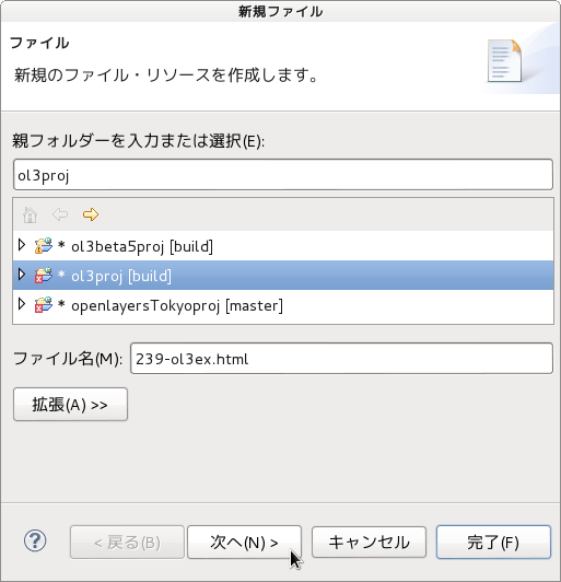
d 「ファイル」ウィンドウで「ol3proj」をクリックして選択し、「ファイル名」を「239-ol3ex.html」と入力し、「次へ」ボタンをクリックします。


e 「File Template」ウィンドウで「HTML 5 Template」をクリックして選択し、「OK」ボタンをクリックします。


f 「vector-labels.html」の内容をコピーして「239-ol3ex.html」に貼り付け、修正します。
g 同じように、新規に「239-ol3ex.js」ファイルを作成し、「File Template」ウィンドウで「JavaScript Template」をクリックして選択し、「完了」ボタンをクリックして、「vector-labels.js」の内容をコピーして貼り付け、修正します。「vector-labels-require.js」も「239-ol3ex-require.js」に貼り付けます。


「239-ol3ex.html」
<!doctype html>
<html lang="en">
 <head>
  <meta charset="utf-8">
  <meta http-equiv="X-UA-Compatible" content="chrome=1">
  <meta name="viewport" content="initial-scale=1.0, user-scalable=no, width=device-width">
<!--
  <link rel="stylesheet" href="../css/ol.css" type="text/css">
  <link rel="stylesheet" href="../resources/bootstrap/css/bootstrap.min.css" type="text/css">
  <link rel="stylesheet" href="../resources/layout.css" type="text/css">
  <link rel="stylesheet" href="../resources/bootstrap/css/bootstrap-responsive.min.css" type="text/css">
-->
  <!-- ディレクトリ修正 -->
  <link rel="stylesheet" href="v3.0.0/css/ol.css" type="text/css">
  <link rel="stylesheet" href="v3.0.0/resources/bootstrap/css/bootstrap.min.css" type="text/css">
  <link rel="stylesheet" href="v3.0.0/resources/layout.css" type="text/css">
  <link rel="stylesheet" href="v3.0.0/resources/bootstrap/css/bootstrap-responsive.min.css" type="text/css">
  <title>Vector labels example</title>
  <style type="text/css">
   h2 {
    font-size: 1.5em;
    line-height: 15px;
   }
   .scale-cnt {
    margin: 5px;
   }
   .edit-form-ctn {
   }
   .edit-form {
    float: left;
    margin: 5px;
    width: 230px;
    padding: 4px;
    border: 1px solid black;
   }
   .edit-form input[type="button"] {
    float: right;
   }
   .edit-form-elem label {
    display: block;
    float: left;
    width: 85px;
   }
   .edit-form-elem input[type="text"] {
    width: 60px;
   }
   .edit-form-elem select {
    width: 130px;
   }
  </style>
 </head>
 <body>
  <!-- 
  bootstrap.min.css, bootstrap-responsive.min.css で設定されたセレクタを使用。
  -->
  <div class="navbar navbar-inverse navbar-fixed-top">
   <div class="navbar-inner">
    <div class="container">
<!--
     <a class="brand" href="./"><img src="../resources/logo.png"> OpenLayers 3 Examples</a>
-->
      <!-- ディレクトリ修正 -->
     <a class="brand" href="v3.0.0/examples/"><img src="v3.0.0/resources/logo.png"> OpenLayers 3 Examples</a>
    </div>
   </div>
  </div>
  <div class="container-fluid">
   <div class="row-fluid">
    <div class="span12">
     <div id="map" class="map"></div>
    </div>
   </div>
   <div class="edit-form">
    <input id="refresh-points" type="button" value="Refresh" />
     <h2>Points</h2>
     <div class="edit-form-elem">
      <label>Text: </label>
      <select id="points-text">
       <option value="hide">Hide</option>
       <option value="normal">Normal</option>
       <option value="shorten" selected="selected">Shorten</option>
       <option value="wrap">Wrap</option>
      </select>
      <br />
      <label title="Max Resolution Denominator">MaxReso.:</label>
      <select id="points-maxreso">
       <option value="38400">38,400</option>
       <option value="19200">19,200</option>
       <option value="9600">9,600</option>
       <option value="4800">4,800</option>
       <option value="2400">2,400</option>
       <option value="1200" selected="selected">1,200</option>
       <option value="600">600</option>
       <option value="300">300</option>
       <option value="150">150</option>
       <option value="75">75</option>
       <option value="32">32</option>
       <option value="16">16</option>
       <option value="8">8</option>
      </select>
      <br />
      <label>Align: </label>
      <select id="points-align">
       <option value="center" selected="selected">Center</option>
       <option value="end">End</option>
       <option value="left">Left</option>
       <option value="right">Right</option>
       <option value="start">Start</option>
      </select>
      <br />
      <label>Baseline: </label>
      <select id="points-baseline">
       <option value="alphabetic">Alphabetic</option>
       <option value="bottom">Bottom</option>
       <option value="hanging">Hanging</option>
       <option value="ideographic">Ideographic</option>
       <option value="middle" selected="selected">Middle</option>
       <option value="top">Top</option>
      </select>
      <br />
      <label>Rotation: </label>
      <select id="points-rotation">
       <option value="0">0°</option>
       <option value="0.785398164">45°</option>
       <option value="1.570796327">90°</option>
      </select>
      <br />
      <label>Font: </label>
      <select id="points-font">
       <option value="Arial" selected="selected">Arial</option>
       <option value="Courier New">Courier New</option>
       <option value="Quattrocento Sans">Quattrocento</option>
       <option value="Verdana">Verdana</option>
      </select>
      <br />
      <label>Weight: </label>
      <select id="points-weight">
       <option value="bold">Bold</option>
       <option value="normal" selected="selected">Normal</option>
      </select>
      <br />
      <label>Size: </label>
      <input type="text" value="12px" id="points-size" />
      <br />
      <label>Offset X:</label>
      <input type="text" value="0" id="points-offset-x" />
      <br />
      <label>Offset Y:</label>
      <input type="text" value="0" id="points-offset-y" />
      <br />
      <label>Color :</label>
      <input type="text" value="#aa3300" id="points-color" />
      <br />
      <label title="Outline Color">O. Color:</label>
      <input type="text" value="#ffffff" id="points-outline" />
      <br />
      <label title="Outline Width">O. Width :</label>
      <input type="text" value="3" id="points-outline-width" />
     </div>
    </div>
    <div class="edit-form">
     <input id="refresh-lines" type="button" value="Refresh" />
     <h2>Lines</h2>
     <div class="edit-form-elem">
      <label>Text: </label>
      <select id="lines-text">
       <option value="hide">Hide</option>
       <option value="normal">Normal</option>
       <option value="shorten">Shorten</option>
       <option value="wrap" selected="selected">Wrap</option>
      </select>
      <br />
      <label title="Max Resolution Denominator">MaxReso.:</label>
      <select id="lines-maxreso">
       <option value="38400">38,400</option>
       <option value="19200">19,200</option>
       <option value="9600">9,600</option>
       <option value="4800">4,800</option>
       <option value="2400">2,400</option>
       <option value="1200" selected="selected">1,200</option>
       <option value="600">600</option>
       <option value="300">300</option>
       <option value="150">150</option>
       <option value="75">75</option>
       <option value="32">32</option>
       <option value="16">16</option>
       <option value="8">8</option>
      </select>
      <br />
      <label>Align: </label>
      <select id="lines-align">
       <option value="center" selected="selected">Center</option>
       <option value="end">End</option>
       <option value="left">Left</option>
       <option value="right">Right</option>
       <option value="start">Start</option>
      </select>
      <br />
      <label>Baseline: </label>
      <select id="lines-baseline">
       <option value="alphabetic">Alphabetic</option>
       <option value="bottom">Bottom</option>
       <option value="hanging">Hanging</option>
       <option value="ideographic">Ideographic</option>
       <option value="middle" selected="selected">Middle</option>
       <option value="top">Top</option>
      </select>
      <br />
      <label>Rotation: </label>
      <select id="lines-rotation">
       <option value="0">0°</option>
       <option value="0.785398164">45°</option>
       <option value="1.570796327">90°</option>
      </select>
      <br />
      <label>Font: </label>
      <select id="lines-font">
       <option value="Arial">Arial</option>
       <option value="Courier New" selected="selected">Courier New</option>
       <option value="Quattrocento Sans">Quattrocento</option>
       <option value="Verdana">Verdana</option>
      </select>
      <br />
      <label>Weight: </label>
      <select id="lines-weight">
       <option value="bold" selected="selected">Bold</option>
       <option value="normal">Normal</option>
      </select>
      <br />
      <label>Size: </label>
      <input type="text" value="12px" id="lines-size" />
      <br />
      <label>Offset X:</label>
      <input type="text" value="0" id="lines-offset-x" />
      <br />
      <label>Offset Y:</label>
      <input type="text" value="0" id="lines-offset-y" />
      <br />
      <label>Color :</label>
      <input type="text" value="green" id="lines-color" />
      <br />
      <label title="Outline Color">O. Color:</label>
      <input type="text" value="#ffffff" id="lines-outline" />
      <br />
      <label title="Outline Width">O. Width :</label>
      <input type="text" value="3" id="lines-outline-width" />
     </div>
    </div>
    <div class="edit-form">
     <input id="refresh-polygons" type="button" value="Refresh" />
     <h2>Polygons</h2>
     <div class="edit-form-elem">
      <label>Text: </label>
      <select id="polygons-text">
       <option value="hide">Hide</option>
       <option value="normal" selected="selected">Normal</option>
       <option value="shorten">Shorten</option>
       <option value="wrap">Wrap</option>
      </select>
      <br />
      <label title="Max Resolution Denominator">MaxReso.:</label>
      <select id="polygons-maxreso">
       <option value="38400">38,400</option>
       <option value="19200">19,200</option>
       <option value="9600">9,600</option>
       <option value="4800">4,800</option>
       <option value="2400">2,400</option>
       <option value="1200" selected="selected">1,200</option>
       <option value="600">600</option>
       <option value="300">300</option>
       <option value="150">150</option>
       <option value="75">75</option>
       <option value="32">32</option>
       <option value="16">16</option>
       <option value="8">8</option>
      </select>
      <br />
      <label>Align: </label>
      <select id="polygons-align">
       <option value="center" selected="selected">Center</option>
       <option value="end">End</option>
       <option value="left">Left</option>
       <option value="right">Right</option>
       <option value="start">Start</option>
      </select>
      <br />
      <label>Baseline: </label>
      <select id="polygons-baseline">
       <option value="alphabetic">Alphabetic</option>
       <option value="bottom">Bottom</option>
       <option value="hanging">Hanging</option>
       <option value="ideographic">Ideographic</option>
       <option value="middle" selected="selected">Middle</option>
       <option value="top">Top</option>
      </select>
      <br />
      <label>Rotation: </label>
      <select id="polygons-rotation">
       <option value="0">0°</option>
       <option value="0.785398164">45°</option>
       <option value="1.570796327">90°</option>
      </select>
      <br />
      <label>Font: </label>
      <select id="polygons-font">
       <option value="Arial">Arial</option>
       <option value="Courier New">Courier New</option>
       <option value="Quattrocento Sans">Quattrocento</option>
       <option value="Verdana" selected="selected">Verdana</option>
      </select>
      <br />
      <label>Weight: </label>
      <select id="polygons-weight">
       <option value="bold" selected="selected">Bold</option>
       <option value="normal">Normal</option>
      </select>
      <br />
      <label>Size: </label>
      <input type="text" value="10px" id="polygons-size" />
      <br />
      <label>Offset X:</label>
      <input type="text" value="0" id="polygons-offset-x" />
      <br />
      <label>Offset Y:</label>
      <input type="text" value="0" id="polygons-offset-y" />
      <br />
      <label>Color :</label>
      <input type="text" value="blue" id="polygons-color" />
      <br />
      <label title="Outline Color">O. Color:</label>
      <input type="text" value="#ffffff" id="polygons-outline" />
      <br />
      <label title="Outline Width">O. Width :</label>
      <input type="text" value="3" id="polygons-outline-width" />
     </div>
    </div>
    <div style="clear:left;"></div>
   <div class="row-fluid">
    <div class="span12">
     <h4 id="title">Vector labels example</h4>
     <p id="shortdesc">Example of GeoJSON features with labels.</p>
     <div id="docs">
<!--
      <p>See the <a href="vector-labels.js" target="_blank">vector-labels.js source</a> to see how this is done.</p>
-->
       <!-- ファイル修正 -->
      <p>See the <a href="239-ol3ex.js" target="_blank">239-ol3ex.js source</a> to see how this is done.</p>
      <p><strong>Note:</strong> The 'Text/Wrap' option is currently
       not working properly.  This is because ol3 uses Canvas's strokeText
       and fillText functions that do not support text wrapping.</p>
     </div>
     <div id="tags">geojson, vector, openstreetmap, label</div>
    </div>
   </div>
  </div>
<!--
  <script src="jquery.min.js" type="text/javascript"></script>
  <script src="../resources/example-behaviour.js" type="text/javascript"></script>
-->
  <!-- ディレクトリ修正
   jQuery Minified版と
   example-behaviour.js(Examples用 JSコード[文字コードなど])
  -->
  <script src="v3.0.0/examples/jquery.min.js" type="text/javascript"></script>
  <script src="v3.0.0/resources/example-behaviour.js" type="text/javascript"></script>
<!--
  <script src="loader.js?id=vector-label" type="text/javascript"></script>
-->
  <!-- ファイル修正 -->  <!-- ディレクトリ修正 -->
  <script src="loader.js?id=239-ol3ex" type="text/javascript"></script>

 </body>
</html>