このメーリングリストにもありますが、次のサイトにも情報があります。
OpenLayers and Proj4js
http://trac.openlayers.org/wiki/Documentation/Dev/proj4js
ここを参考にして、Proj4js を設定します。
1 ダウンロード
1-1 Proj4js サイト
http://trac.osgeo.org/proj4js/
の「Download」をクリックします。
1-2 Download-Proj4js
http://trac.osgeo.org/proj4js/wiki/Download
の「Attachments」の「proj4js-1.0.0-RC2.zip」をクリックします。
1-3 Download: proj4js-1.0.0-RC2.zip
http://trac.osgeo.org/proj4js/attachment/wiki/Download/proj4js-1.0.0-RC2.zip
の「download the file」をクリックしてダウンロードします。
2 インストール
2-1 ダウンロードした proj4js-1.0.0-RC2.zip を解凍します。
~/$ unzip proj4js-1.0.0-RC2.zip
2-2 解凍されたフォルダの proj4js/lib/def/ に定義ファイルがあるので、EPSG:4326 と EPSG:2456 がないときは作成します。
EPSG4302.js を参考にします。
データは、/usr/share/proj のものを使用します。
nob61@debian:/usr/share/proj$ grep -A1 4326 epsg
<4326> +proj=longlat +ellps=WGS84 +datum=WGS84 +no_defs  <>
# Anguilla 1957
nob61@debian:/usr/share/proj$ grep -A1 JGD2000 epsg
---
# JGD2000 / Japan Plane Rectangular CS XIV
<2456> +proj=tmerc +lat_0=26 +lon_0=142 +k=0.9999 +x_0=0 +y_0=0 +ellps=GRS80 +towgs84=0,0,0,0,0,0,0 +units=m +no_defs  <>
---
定義ファイルの内容
EPSG4326.js
Proj4js.defs["EPSG:4326"]= "+title= WGS84 EPSG:4326 +proj=longlat +ellps=WGS84 +datum=WGS84 +no_defs";
EPSG2456.js
Proj4js.defs["EPSG:2456"]= "+title= JGD2000 Japan Plane Rectangular CS IX EPSG:4326 +proj=tmerc +lat_0=26 +lon_0=142 +k=0.9999 +x_0=0 +y_0=0 +ellps=GRS80 +towgs84=0,0,0,0,0,0,0 +units=m +no_defs";
定義ファイルの確認
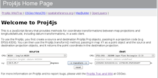
proj4js/index.html ファイルの内容を修正します。
---
<script src="lib/defs/EPSG900913.js"></script>
<script src="lib/defs/EPSG2456.js"></script><!-- ここを追加 -->

<script type="text/javascript">
---
このファイルをブラウザで開いて、
「source」を「WGS84 - long/lat:WGS84」、
「dest」を「EPSG:2456 - JGD2000 Japan Plane Rectangular CS IX」
にして変換してみます。


0 件のコメント:
コメントを投稿