Example サイト
http://www.geoext.org/examples.html
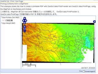
「Print Your Page」リンクをクリックすると Printing Contents from a MapPanel が表示されます。
print-page.js. を参考にします。
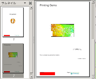
説明を意訳すると、GeoExt.data.PrintProvider と GeoExt.data.PrintPage で印刷可能な PDF を作成する方法を示します。
初めに、GeoServer Printing Module サイト
http://docs.geoserver.org/stable/en/user/community/printing/
に従って GeoServer プリントモジュールをインストールします。
1 Installation の「nighty build server」をクリックします。
2 geoserver-2.0.3-SNAPSHOT-printing-plugin.zip をクリックしてダウンロードします。
3 2 の ZIP ファイルを /WEB-INF/lib/ に解凍します。
(私の場合は、/home/user/geoserver-2.0.1/webapps/geoserver/WEB-INF/lib/ です)
4 GeoServer を再起動します。
5 http://localhost:8080/geoserver/pdf/info.json で設定されているで印刷プロパティの一覧がダウンロードされるのを確認してください。
var mapPanel, printPage;

Ext.onReady(function() {
 // The printProvider that connects us to the print service
 var printProvider = new GeoExt.data.PrintProvider({
  method: "GET", // "POST" recommended for production use "GET"
  capabilities: printCapabilities // from the info.json script in the html
 });
 // Our print page. Tells the PrintProvider about the scale and center of
 // our page.
 printPage = new GeoExt.data.PrintPage({
  printProvider: printProvider,
  customParams: {
   mapTitle: "Printing Demo",
   comment: "This is a simple map printed from GeoExt."
  }
 });
 // The map we want to print
 // 東京都用マップ設定
 var map = new OpenLayers.Map('map', {
  controls: [
   new OpenLayers.Control.PanZoom(),
   new OpenLayers.Control.LayerSwitcher(),
   new OpenLayers.Control.MousePosition(),
   new OpenLayers.Control.ScaleLine()
  ],
  projection: new OpenLayers.Projection("EPSG:2456"),
  maxResolution: 'auto', //'367.1875', '183.594',
  maxExtent: new OpenLayers.Bounds(-279000,1054000,-185000,1104000),
  units: 'meters',
  displayProjection: new OpenLayers.Projection("EPSG:4326")
 });
 mapPanel = new GeoExt.MapPanel({
  region: "center",
//  layers: [new OpenLayers.Layer.WMS("Tasmania", "http://demo.opengeo.org/geoserver/wms",
//  {layers: "topp:tasmania_state_boundaries"}, {singleTile: true})],
  layers: [
   // 東京都レイヤ
   new OpenLayers.Layer.WMS( "Tokyo Height WMS",
    "http://192.168.1.6/cgi-bin/mapserv?",
    {
     map: '/home/user/mapfile/tokyo_bmi_pgis_img2.map',
     layers: 'height',
     format: 'image/png'
    }, {
      singleTile: true
   }),
   new OpenLayers.Layer.WMS( "Tokyo Kukaku Sen WMS",
    "http://192.168.1.6/cgi-bin/mapserv?",
    {
     map: '/home/user/mapfile/tokyo_bmi_pgis_img2.map',
     layers: 'kukaku',
     transparent: true,
     format: 'image/png'
    }, {
     singleTile: true
   })
  ],
//  center: [146.56, -41.56],
//  zoom: 7
  map: map
 });
 // The legend to optionally include on the printout
 var legendPanel = new GeoExt.LegendPanel({
  region: "west",
  width: 150,
  bodyStyle: "padding:5px",
  layerStore: mapPanel.layers
 });

 var includeLegend; // controlled by the "Include legend?" checkbox

 // The main panel
 new Ext.Panel({
  renderTo: "content",
  layout: "border",
  width: 700,
  height: 420,
  items: [mapPanel, legendPanel],
  bbar: ["->", {
   text: "Print",
   handler: function() {
    // convenient way to fit the print page to the visible map area
    printPage.fit(mapPanel, true);
    // print the page, optionally including the legend
    printProvider.print(mapPanel, printPage, includeLegend && {legend: legendPanel});
   }
  }, {
   xtype: "checkbox",
   boxLabel: "Include legend?",
   handler: function() {includeLegend = this.checked}
  }]
 });
});
HTML ファイルを新規作成します。
「openlayersTokyoproj」 を右クリックして 新規 -> HTML ファイル をクリック。
「HTML ファイル」ウィンドウの「ファイル名(任意:geoext24_print-page.html)」に入力して「完了」ボタンをクリック。
「charset」を「utf-8」にします。
以下のように HTML を作成します。
geoext23_vector-legend.html をコピーし、外部 JavaScript 読み込みファイルを修正しプリントモジュールを設定し body タグ内にターゲット id を設定します。
---
  <title>GeoExt24 Print Your Page</title>
---
<!-- print-page.js 追加 -->
  <script type="text/javascript" src="./print-page.js"></script>

  <!-- The script below will load the capabilities of the print service
  and save them into the global printCapabilities variable. Instead
  of this, the PrintProvider can be configured with a url and take
  care of fetching the capabilities. -->
  <!--
  <script type="text/javascript" src="http://demo.opengeo.org/geoserver/pdf/info.json?var=printCapabilities"></script>
  -->
  <script type="text/javascript" src="http://192.168.1.6:8080/geoserver/pdf/info.json?var=printCapabilities"></script>

 </head>
 <body>

  <h1 id="title">GeoExt 24 - Print Your Page</h1>
  <p id="shortdesc">
   Printing Contents from a MapPanel
  </p>
  <p>This example shows the how to create a printable PDF with
   GeoExt.data.PrintProvider and GeoExt.data.PrintPage,
   using the MapFish or GeoServer  print module.</p>

  <p>この例では、MapFish または GeoServer 印刷モジュールを使用して、
   GeoExt.data.PrintProvider と GeoExt.data.PrintPage で印刷可能な PDF を
   作成する方法を示します。</p>

  <div id="content"></div>

 </body>
</html>


0 件のコメント:
コメントを投稿