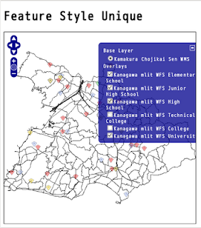
国土数値情報の公共施設の説明から、小分類コードしたがって学校に関するデータをレイヤ別に表示します。
公共施設小分類コード 〈ファイル名称:PubFacMiclassCd〉
コード  対応する内容
16001  小学校
16002  中学校
16003  中等教育学校
16004  高等学校
16005  高等専門学校
16006  短期大学
16007  大学
16008  盲学校
16009  ろう学校
16010  養護学校
16011  幼稚園
kanagawa_mlit_pgis_pf.map の学校(school)レイヤを変更します。
1 kanagawa_mlit_pgis_pf.map をコピーしてファイル名を kanagawa_mlit_pgis_school.map にします。
user@debian:~/mapfile$ cp kanagawa_mlit_pgis_pf.map kanagawa_mlit_pgis_school.map
2 学校(school)レイヤを除いた次のレイヤを削除します。
building
national_office
local_office
police
fire_station
hospital
post
3 学校(school)レイヤを次のように変更します。
---
 LAYER
   NAME elementary_school
   GROUP elementary_school
   TYPE POINT
   STATUS ON
   DUMP TRUE
   CONNECTIONTYPE POSTGIS
   CONNECTION "dbname=kanagawa_mlit host=localhost user=user password=password"
   DATA "the_geom from (select * from publicfacilities where pci = '16001' and aac = '14204') as kanagawaquery using unique gid using srid = -1" #1
#   MINSCALE 1000
#   MAXSCALE 1000000000
#   MAXSCALEDENOM 100000
   LABELITEM "na0"
   METADATA
     "wfs_title" "PF Elementary School Kanagawa mlit WFS Layer" #2
     "wfs_srs" "EPSG:4612"
     "gml_featureid" "gid"
     "gml_include_items" "all"
     "gml_exclude_items" ""
     "group_title" "小学校"
     "searchfield" "na0"
     "fields" "na0:小学校,ads:住所"
   END
   CLASS
     NAME "小学校"
---
#1 SQLクエリを使用して「鎌倉市」の「小学校」のデータを抽出します。
select * from publicfacilities where pci = '16001' and acc = '14204'
サブクエリで select文で publicfacilitiesテーブルのうち、pci列が16001でaac列が14204のデータの要素をすべて抽出します。
#2 WFS の設定。
"wfs_title" "PF Elementary School Kanagawa mlit WFS Layer"
各レイヤの相違部分
LAYER NAME GROUP  pci    wfs_title
erementary_school 16001  PF Elementary School Kanagawa mlit WFS Layer
juniorhigh_school 16002  PF Junior High School Kanagawa mlit WFS Layer
juniorhigh_school 16003  PF Junior High School Kanagawa mlit WFS Layer
 where (pci = '16002' or pci = '16003') and aac = '14204'
high_school       16004  PF High School Kanagawa mlit WFS Layer
technical_college 16005  PF Technical College Kanagawa mlit WFS Layer
college           16006  PF College Kanagawa mlit WFS Layer
university        16007  PF University Kanagawa mlit WFS Layer
feature_style_basic.html を参考に地図を作成します。
0 feature_style_basic.html をダブルクリックして開きます。
1 プロジェクトビューのOpenLayersprojフォルダを右クリックして、新規->HTMLファイルをクリックします。
2 HTMLファイルウィンドウでファイル名をfeature_style_unique.htmlと入力し、終了ボタンをクリックします。
3 エディタのタブをエディタビュー内の下へドラッグすると2段になってみやすくなります。
4 charsetをUTF-8にして、<title>をFeature Style Uniqueにします。
5 feature_style_basic.htmlの内容をコピーしてfeature_style_unique.html ファイルに貼り付け修正します。
#1 表示レイヤの定義を修正します。
#2 範囲を鎌倉市に合わせて変更します。
#3 layer1 の鎌倉市の丁字界線はコメントアウトははずします。
#3 layer2 の神奈川県の行政区画線はコメントアウトします。
---
<title>Feature Style Unique</title>
<link rel="stylesheet" href="theme/default/style.css" type="text/css" />
<style type="text/css">
    #map {
        width: 512px;
        height: 512px;
        border: 1px solid black;
    }
</style>
<script src="lib/OpenLayers.js"></script>
<script type="text/javascript">
// #1表示レイヤの定義を修正
    var map, layer1, layer3, layer4, layer5, layer6, layer7, layer8;

    function init(){
  OpenLayers.ProxyHost="/cgi-bin/proxy.cgi?url=";
        map = new OpenLayers.Map('map',  {
  maxResolution: 'auto',
  units: 'meters',
// #2 範囲を鎌倉市に合わせて変更
  maxExtent: new OpenLayers.Bounds(-31337.715508,-77650.134635,-21796.513842,-70055.061952)
  }
 );
// #3 layer1 の鎌倉市の丁字界線はコメントアウトははずします。
//    layer2 の神奈川県の行政区画線はコメントアウトします。
       layer1 = new OpenLayers.Layer.WMS( "Kamakura Chojikai Sen WMS",
               "http://localhost/cgi-bin/mapserv?",
  {
    map: '/home/nob61/mapfile/kamakura_pgis.map',
   layers: 'chojisen',
//   transparent: true,
   format: 'image/png'
  },
  {
   projection: 'EPSG:2451'
  }
 );

/*     layer2 = new OpenLayers.Layer.WMS( "Kanagawa Gyosei Kukaku Sen WMS",
               "http://localhost/cgi-bin/mapserv?",
  {
   map: '/home/nob61/mapfile/kanagawa_pgis.map',
   layers: 'kukaku',
   format: 'image/png'
  },
  {
   projection: 'EPSG:2451'
  }
 );
*/
---
6 kanagawa_mlit_pgis_school.map の elementary_school レイヤように次のように追加します。
---
var style_markRed = OpenLayers.Util.extend({}, OpenLayers.Feature.Vector.style['default']);
  style_markRed.graphicWidth = 15;  //画像の幅
  style_markRed.graphicHeight = 15; //画像の高さ
  style_markRed.graphicXOffset = -(style_markRed.graphicWidth/2);
//画像を横方向に画像幅の半分ずらす
  style_markRed.graphicYOffset = -style_markRed.graphicHeight;
//画像を縦方向に画像高さ分のずらす
  style_markRed.externalGraphic = "./img/marker.png"; //画像のパス
layer3 = new OpenLayers.Layer.WFS( "Kanagawa mlit WFS Elementary School",
   "http://localhost/cgi-bin/mapserv?",
  {
   map: '/home/nob61/mapfile/kanagawa_mlit_pgis_school.map',
   typename: 'elementary_school'
  },
  {
   style: style_markRed,
   visibility: false,
   projection: 'EPSG:4612'
  }
);
---
7他のレイヤも同様に追加します。
LAYER NAME        style            extarnalGraphic  name
juniorhigh_school style_markRed    ./img/marker.png Kanagawa mlit WFS Junior High School
high_school       style_markBlue   ./img/marker.png Kanagawa mlit WFS High School
university        style_markGreen  ./img/marker.png Kanagawa mlit WFS University
次のレイヤは円で表示しました。(鎌倉市にはデータがありませんでした。)
LAYER NAME        style              fillColor strokeColor name
technical_college style_lightsyan    #99ffff   #33ffff     Kanagawa mlit WFS Technical College
college           style_lightmagenta #ff99ff   #ff33ff     Kanagawa mlit WFS College
8 地図表示部分を次のようにします。
---
 map.addLayers([layer1, layer3, layer4, layer5, layer6, layer7, layer8]);
 map.addControl(new OpenLayers.Control.LayerSwitcher());
 map.zoomToMaxExtent();
    }
    </script>
  </head>
  <body onload="init()">
    <h1 id="title">Feature Style Unique</h1>

    <div id="map"></div>

  </body>
</html>
9 Webブラウザを起動して、アドレスバーに次のように入力します。
http://localhost/openlayers/OpenLayersproj/feature_style_unique.html


0 件のコメント:
コメントを投稿