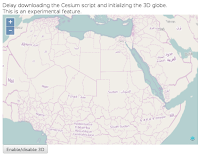
「lazy.js(13-ol3cesium18.js)」は、マップを表示するための JavaScript ファイルです。
OL3-Cesium API は、現在、すべて実験的(experimental)なものです。
「13-ol3cesium18.js」
var ol2d = new ol.Map({
 layers: [
  new ol.layer.Tile({
  /** ol.layer.Tile
   * For layer sources that provide pre-rendered, tiled
   * images in grids that are organized by zoom levels for
   * specific resolutions.
   * プリレンダリング(事前描画)を提供するレイヤソースのための、
   * 特定の解像度でのズームレベルによって編成されているグリッドの
   * タイルイメージ。(ol3 API)
   */
   source: new ol.source.OSM()
   /** ol.source.OSM
    * Layer source for the OpenStreetMap tile server.
    * OpenStreetMap タイルサーバのレイヤソース。(ol3 API)
    */
  })
 ],
 controls: ol.control.defaults({
 /** controls
  * Controls initially added to the map.
  * If not specified, ol.control.defaults() is used.
  * 初期設定で、マップに追加されたコントロール。
  * 明示されていなければ、ol.control.defaults() が使用されます。
  * (ol3 API)
  */
 /** ol.control.defaults()
  * デフォルトでは、マップに含まコントロールのセット。
  * 特に設定しない限り、これは、以下の各コントロールの
  * インスタンスを含むコレクションを返します。(ol3 API)
  * ol.control.Zoom, ol.control.Rotate, ol.control.Attribution
  */
  attributionOptions: /** @type {olx.control.AttributionOptions} */ ({
  /** @type
   * 値のタイプ(型)の説明 - 式などで表示
   * (@use JSDoc[http://usejsdoc.org/]より)
   */
   collapsible: false // 折りたたみ
  })
 }),
 target: 'map',
 view: new ol.View({
  center: ol.proj.transform([25, 20], 'EPSG:4326', 'EPSG:3857'),
  /** ol.proj.transform(coordinate, source, destination)
   * Transforms a coordinate from source projection to
   * destination projection. This returns a new coordinate
   * (and does not modify the original).
   * ソース投影から変換先投影に座標変換します。これは、新しい座標
   * を返します(オリジナルを変更しません)。(ol3 API)
   */
  zoom: 3
 })
});

var ol3d;

function _doToggle() {
 ol3d.setEnabled(!ol3d.getEnabled());
 /** setEnabled(enable)
  * Enables/disables the Cesium. This modifies the
  * visibility style of the container element.
  * セシウムを有効または無効にします。これは、コンテナ要素の可視
  * 性スタイルを変更します。
  * (OL3-Cesium API)
  */
 /** getEnabled()
  * (OL3-Cesium API に説明がありませんでした。)
  */
}
function toggle3D() {
 if (!ol3d) {
  var s = document.createElement("script");
  /** document.createElement
   * 指定の要素名の要素を生成します。
   * (MDN[https://developer.mozilla.org/ja/docs/Web/
   * API/document.createElement)
   */
  s.type = "text/javascript";
  // s.src = "../Cesium/Cesium.js";
  s.src = "./js/libs/ol3-cesium-v1.8/Cesium/Cesium.js";
  console.log('loading Cesium...');
  s.onload = function() {
  /** window.onload
   * window の load イベントに対応するイベントハンドラです。
   * (MDN[https://developer.mozilla.org/ja/docs/Web/API/
   * GlobalEventHandlers/onload])
   */
   init3D();
   _doToggle();
  };
  document.body.appendChild(s);
  /** Node.appendChild
   * 特定の親ノードの子ノードリストの末尾にノードを追加します。
   * 追加しようとしたノードが既に存在していたら、それは現在の
   * 親ノードから除かれ、新しい親ノードに追加されます。
   * (MDN[https://developer.mozilla.org/ja/docs/Web/
   * API/Node.appendChild])
   */
 } else {
  _doToggle();
 }
}
function init3D() {
 ol3d = new olcs.OLCesium({map: ol2d});
 /** new olcs.OLCesium(options)
  * map: The OpenLayers map we want to show on a Cesium
  * scene.
  * Cesium シーンで表示したい OpenLayers マップ。
  * (OL3-Cesium API)
  */
 var scene = ol3d.getCesiumScene();
 /** getCesiumScene()
  * (OL3-Cesium API に説明がありませんでした。)
  */
 var terrainProvider = new Cesium.CesiumTerrainProvider({
 /** new CesiumTerrainProvider(options)
  * A TerrainProvider that access terrain data in a Cesium
  * terrain format. The format is described on the Cesium
  * wiki.
  * セシウム地形(Cesium terrain)フォーマットの地形(terrain)
  * データにアクセスする TerrainProvider。フォーマットは、セシウ
  * ムウィキに記載されています。
  * (Cesium refdoc)
  */
  // url : '//cesiumjs.org/stk-terrain/tilesets/world/tiles'
  // 2015.10.2 変更
  url : '//assets.agi.com/stk-terrain/world'
  /** url
   * The URL of the Cesium terrain server.
   * セシウム地形(Cesium terrain)サーバの URL。
   * (Cesium refdoc)
   */
 });
 scene.terrainProvider = terrainProvider;
}
Chromium では表示できないので、Iceweasel(Firefox)のアドレスバーに
http://localhost/~user/ol3cesiumproj/public_html/13-ol3cesium18.html
と入力して表示します。


0 件のコメント:
コメントを投稿