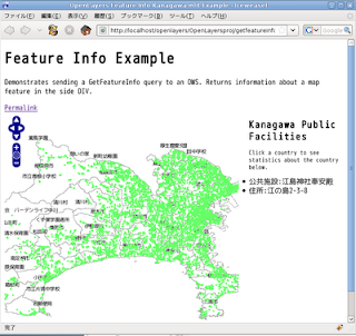
0 getfeatureinfo.htmlをダブルクリックして開きます。
1 プロジェクトビューのOpenLayersprojフォルダを右クリックして、新規->HTMLファイルをクリックします。
2 HTMLファイルウィンドウでファイル名をgetfeatureinfo_kanagawamlit.htmlと入力し、終了ボタンをクリックします。
3 エディタのタブをエディタビュー内の下へドラッグすると2段になってみやすくなります。
4 charsetをUTF-8にして、<title>をFeature Info Kanagawa mlit Mapにします。
5 getfeatureinfo.html の内容ををコピーしてgetfeatureinfo_kanagawamlit.html ファイルに貼り付けます。
6 javascriptの一部を次のように修正します。
style.cssとOpenLayers.jsのパスを変えます。
gyoseikai(行政界)レイヤとpublic_facilities(公共施設)レイヤを設定します。
<html>
 <head>
  <meta http-equiv="Content-Type" content="text/html; charset=utf-8" />
  <title>OpenLayers Feature Info Kanagawa mlit Example</title>
  <script src="./lib/OpenLayers.js"></script>
  <link rel="stylesheet" href="./theme/default/style.css" type="text/css" />
  <style type="text/css">
   ul, li { padding-left: 0px; margin-left: 0px; }

  </style>
 </head>
 <body>
  <h1 id="title">Feature Info Kanagawa mlit Map</h1>

  <div id="tags"></div>

  <p id="shortdesc">
   Demonstrates sending a GetFeatureInfo query to an OWS. Returns information about a map feature in the side DIV.
  </p>

  <a id="permalink" href="">Permalink</a><br />

  <!-- 結果表示欄 -->
  <div style="float:right;width:28%">
   <h1 style="font-size:1.3em;">Kanagawa Public Facilities</h1>
   <p style="font-size:.8em;">Click a country to see statistics about the country below.</p>
   <div id="nodeList"></div>
  </div>
  <div id="map" style="width:512px; height:512px"></div>

  <!--地図表示 -->
  <script defer="defer" type="text/javascript">
   OpenLayers.ProxyHost = "/cgi-bin/proxy.cgi?url=";
   var map = new OpenLayers.Map('map' /*, {'maxResolution':'auto'}*/);

   //行政界(郡市区町村界)レイヤ
   var layer = new OpenLayers.Layer.WMS( "OpenLayers WMS",
    "http://localhost/cgi-bin/mapserv?",
    {
     map: '/home/user/mapfile/kanagawa_mlit_pgis.map',
     layers: 'gyoseikai',
     format: 'image/png'
    },
    {
     projection: 'EPSG:2451'
    }
   );
   map.addLayer(layer);

   //公共施設レイヤ
   var wms = new OpenLayers.Layer.WMS( "OpenLayers WMS",
    "http://localhost/cgi-bin/mapserv?",
    {
     map: '/home/user/mapfile/kanagawa_mlit_pgis.map',
     layers: 'public_facilities',
     transparent: true,
     format: 'image/png'
    },
    {
     projection: 'EPSG:2451'
    }
   );
   map.addLayer(wms);
   map.setCenter(new OpenLayers.LonLat(139.375, 35.4), 10);
   map.addControl(new OpenLayers.Control.Permalink('permalink'));

   map.events.register('click', map, function (e) {
    OpenLayers.Util.getElement('nodeList').innerHTML = "Loading... please wait...";
    var url =  wms.getFullRequestString({
                    REQUEST: "GetFeatureInfo",
                    EXCEPTIONS: "application/vnd.ogc.se_xml",
                    BBOX: wms.map.getExtent().toBBOX(),
                    X: e.xy.x,
                    Y: e.xy.y,
                    INFO_FORMAT: 'text/html',
                    QUERY_LAYERS: wms.params.LAYERS,
                    WIDTH: wms.map.size.w,
                    HEIGHT: wms.map.size.h});
    OpenLayers.loadURL(url, '', this, setHTML);
    OpenLayers.Event.stop(e);
   });
  function setHTML(response) {
    OpenLayers.Util.getElement('nodeList').innerHTML = response.responseText;
   }
  </script>

  <div id="docs"></div>
 </body>
</html>
クリックでイベントが発生したときに、その時の地図の範囲、クリックした位置、マップサーバーからの情報のフォーマット、レイヤのパラメータ(属性)、地図の縦横の長さを受け取ります。
このデータから該当するパラメータが表示されます。


0 件のコメント:
コメントを投稿