http://www.geoext.org/examples.html
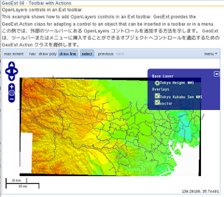
「Toolbar with Actions」リンクをクリックすると OpenLayers controls in an Ext toolbar が表示されます。
toolbar.js を参考にします。
説明を意訳すると、GeoExt.Action クラスを使って OpenLayers コントロールを追加する方法を示します。
JS ファイルを新規作成します。
「openlayersTokyoproj」 を右クリックして 新規 -> JavaScript ファイル をクリック。
「JavaScript ファイル」ウィンドウの「ファイル名(任意:toolbar.js)」に入力して「完了」ボタンをクリック。
GeoExt 06 で使用したレイヤの例を参考に以下のように JavaScript を作成します。
Ext.onReady(function() {
 Ext.QuickTips.init();

// var map = new OpenLayers.Map();
 var map = new OpenLayers.Map('map', {
  controls: [
   new OpenLayers.Control.PanZoom(),
   new OpenLayers.Control.LayerSwitcher(),
   new OpenLayers.Control.MousePosition(),
   new OpenLayers.Control.ScaleLine()
  ],
  allOverlays: false,
  projection: new OpenLayers.Projection("EPSG:2456"),
  maxResolution: 'auto', // '183.594', '367.1875',
  maxExtent: new OpenLayers.Bounds(-279000,1054000,-185000,1104000),
  units: 'meters',
  displayProjection: new OpenLayers.Projection("EPSG:4326")
 });
/*
 var wms = new OpenLayers.Layer.WMS(
  "Global Imagery",
  "http://maps.opengeo.org/geowebcache/service/wms",
  {layers: "bluemarble"}
 );
*/
 var layer1 = new OpenLayers.Layer.WMS( "Tokyo Height WMS",
  "http://192.168.1.6/cgi-bin/mapserv?",
  {
   map: '/home/nob61/mapfile/tokyo_bmi_pgis_img2.map',
   layers: 'height',
// isBaselayer: true,
   format: 'image/png'
 });
 var layer2 = new OpenLayers.Layer.WMS( "Tokyo Kukaku Sen WMS",
  "http://192.168.1.6/cgi-bin/mapserv?",
  {
   map: '/home/nob61/mapfile/tokyo_bmi_pgis_img2.map',
   layers: 'kukaku',
   transparent: true,
   format: 'image/png'
 });
 var vector = new OpenLayers.Layer.Vector("vector");
// map.addLayers([wms, vector]);
 map.addLayers([layer1, layer2, vector]);
 var ctrl, toolbarItems = [], action, actions = {};
 // コントロールボタンを追加するツールバー

 // ZoomToMaxExtent control, a "button" control
 action = new GeoExt.Action({ // OpenLayers コントロールを追加
  control: new OpenLayers.Control.ZoomToMaxExtent(),
  map: map,
  text: "max extent",
  tooltip: "zoom to max extent"
 });
 actions["max_extent"] = action;
 toolbarItems.push(action);
 toolbarItems.push("-");
 // Navigation control and DrawFeature controls
 // in the same toggle group
 action = new GeoExt.Action({
  text: "nav",
  control: new OpenLayers.Control.Navigation(), // パン・ズーム
  map: map,
  // button options
  toggleGroup: "draw", // 同一グループは同時に動作しない
  allowDepress: false,
  pressed: true,
  tooltip: "navigate",
  // check item options
  group: "draw",
  checked: true
 });
 actions["nav"] = action;
 toolbarItems.push(action);
 action = new GeoExt.Action({
  text: "draw poly",
  control: new OpenLayers.Control.DrawFeature( // ポリゴン(面)描画
   vector, OpenLayers.Handler.Polygon
  ),
  map: map,
  // button options
  toggleGroup: "draw",
  allowDepress: false,
  tooltip: "draw polygon",
  // check item options
  group: "draw"
 });
 actions["draw_poly"] = action;
 toolbarItems.push(action);
 action = new GeoExt.Action({
  text: "draw line",
  control: new OpenLayers.Control.DrawFeature( // パス(線)描画
   vector, OpenLayers.Handler.Path
  ),
  map: map,
  // button options
  toggleGroup: "draw",
  allowDepress: false,
  tooltip: "draw line",
  // check item options
  group: "draw"
 });
 actions["draw_line"] = action;
 toolbarItems.push(action);
 toolbarItems.push("-");
 // SelectFeature control, a "toggle" control
 action = new GeoExt.Action({
  text: "select",
  control: new OpenLayers.Control.SelectFeature(vector, { // 選択
   type: OpenLayers.Control.TYPE_TOGGLE,
   hover: true
  }),
  map: map,
  // button options
  enableToggle: true,
  tooltip: "select feature"
 });
 actions["select"] = action;
 toolbarItems.push(action);
 toolbarItems.push("-");
 // Navigation history - two "button" controls
 ctrl = new OpenLayers.Control.NavigationHistory(); // 前(次)画面
 map.addControl(ctrl);

 action = new GeoExt.Action({
  text: "previous",
  control: ctrl.previous,
  disabled: true,
  tooltip: "previous in history"
 });
 actions["previous"] = action;
 toolbarItems.push(action);

 action = new GeoExt.Action({
  text: "next",
  control: ctrl.next,
  disabled: true,
  tooltip: "next in history"
 });
 actions["next"] = action;
 toolbarItems.push(action);
 toolbarItems.push("->");
 // Reuse the GeoExt.Action objects created above
 // as menu items
 toolbarItems.push({
  text: "menu",
  menu: new Ext.menu.Menu({
   items: [
    // ZoomToMaxExtent
    actions["max_extent"],
    // Nav
    new Ext.menu.CheckItem(actions["nav"]),
    // Draw poly
    new Ext.menu.CheckItem(actions["draw_poly"]),
    // Draw line
    new Ext.menu.CheckItem(actions["draw_line"]),
    // Select control
    new Ext.menu.CheckItem(actions["select"]),
    // Navigation history control
    actions["previous"],
    actions["next"]
   ]
  })
 });
 var mapPanel = new GeoExt.MapPanel({
  renderTo: "mappanel",
  height: 400,
  width: 600,
  map: map,
//  center: new OpenLayers.LonLat(5, 45),
//  zoom: 4,
  tbar: toolbarItems
 });
});
HTML ファイルを新規作成します。
「openlayersTokyoproj」 を右クリックして 新規 -> HTML ファイル をクリック。
「HTML ファイル」ウィンドウの「ファイル名(任意:geoext08_map-tool.html)」に入力して「完了」ボタンをクリック。
「charset」を「utf-8」にします。
以前使用した OpenLayers.Layer.WMS レイヤの例を参考に以下のように HTML を作成します。
(geoext05_layer-tree.html をコピーし tree.js を追加し body タグ内を修正します。)
---
  <title>GeoExt08 Toolbar with Actions</title>
---
<!-- tool.js 追加 -->
  <script type="text/javascript" src="./tool.js"></script>

<!-- スタイルシート 追加 -->
  <style type="text/css">
/* work around an Ext bug that makes the rendering of
   menu items not as one would expect */
   .ext-ie .x-menu-item-icon {
     left: -24px;
   }
   .ext-strict .x-menu-item-icon {
    left: 3px;
   }
   .ext-ie6 .x-menu-item-icon {
    left: -24px;
   }
   .ext-ie7 .x-menu-item-icon {
    left: -24px;
   }
  </style>

 </head>
 <body>
   <h1 id="title">GeoExt 08 Toolbar with Actions - OpenLayers コントロールを追加</h1>
   <p id="shortdesc">
    OpenLayers controls in an Ext toolbar
   </p>
   <p>This example shows how to add OpenLayers controls in an
   Ext toolbar.
   GeoExt provides the GeoExt.Action class for adapting a control
   to an object that can be inserted in a toolbar or in a menu.<p>
   <p>この例では、外部のツールバーにある OpenLayers コントロールを追加する
   方法を示します。
   GeoExtは、ツールバーまたはメニューに挿入することができるオブジェクトへ
    コントロールを適応するための  GeoExt.Action クラスを提供します。</p>

   <div id="mappanel"></div>

  </body>
</html>


0 件のコメント:
コメントを投稿