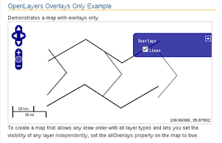
HTML ファイルを新規作成します。
「openlayersTokyoproj」 を右クリックして 新規 -> HTML ファイル をクリック。
「HTML ファイル」ウィンドウの「ファイル名(任意:openlayers_all-overlays.html)」に入力して「完了」ボタンをクリック。
「charset」を「utf-8」にします。
「examples」の「all-overlays.html」の内容をコピーして新規作成したファイルに貼り付けます。
コードの修正とちょっと解説します。
<html xmlns="http://www.w3.org/1999/xhtml">
 <head>
  <meta http-equiv="Content-Type" content="text/html; charset=utf-8">
  <title>OpenLayers34 All Overlays</title>
  <link rel="stylesheet" href="./theme/default/style.css" type="text/css" />
  <link rel="stylesheet" href="./examples/style.css" type="text/css" />

<!-- OpenLayers ライブラリ -->
  <script src="./lib/Firebug/firebug.js"></script>
  <script src="./lib/OpenLayers.js"></script>

<!-- Proj4js ライブラリ -->
  <script type="text/javascript" src="./lib/proj4js/lib/proj4js-compressed.js"></script>
  <script type="text/javascript" src="./lib/proj4js/lib/projCode/tmerc.js"></script>
  <script type="text/javascript" src="./lib/proj4js/lib/defs/EPSG2456.js"></script>
<!-- All Overlay コード -->
  <script type="text/javascript">
   var map;
   function init() {
//  東京都用 map の設定
    map = new OpenLayers.Map('map', {
     allOverlays: true, // ここ
     projection: new OpenLayers.Projection("EPSG:2456"),
     displayProjection: new OpenLayers.Projection("EPSG:4326"),
     maxResolution: 'auto',
     units: 'meters',
     maxExtent: new OpenLayers.Bounds(-279000,1054000,-185000,1104000)
    });
// ここまで
// give the features some style
    var styles = new OpenLayers.StyleMap({
     "default": {
      strokeWidth: 2
     },
     "select": {
      strokeColor: "#0099cc",
      strokeWidth: 4
     }
    });
// add rules from the above lookup table
    styles.addUniqueValueRules("default", "RP_TYPE", {
     10: {strokeColor: "#000000", strokeWidth: 2},
     12: {strokeColor: "#222222", strokeWidth: 2},
     14: {strokeColor: "#444444", strokeWidth: 2},
     16: {strokeColor: "#666666", strokeWidth: 2},
     18: {strokeColor: "#888888", strokeWidth: 2},
     19: {strokeColor: "#666666", strokeWidth: 1}
    });

    var vectors = new OpenLayers.Layer.Vector("Lines", {
     strategies: [new OpenLayers.Strategy.Fixed()],
     protocol: new OpenLayers.Protocol.HTTP({
      url: "ol27_line2.json", // 修正
      format: new OpenLayers.Format.GeoJSON({
       internalProjection: new OpenLayers.Projection("EPSG:2456"), // 追加
       externalProjection: new OpenLayers.Projection("EPSG:4326")  // 追加
      })
     }),
     styleMap: styles
    });

    map.addLayer(vectors);
    map.addControl(new OpenLayers.Control.LayerSwitcher());
    map.addControl(new OpenLayers.Control.MousePosition()); // 追加
    map.addControl(new OpenLayers.Control.ScaleLine());     // 追加
    map.zoomToMaxExtent();

   } // End of function init()
  </script>
 </head>
<!-- body 部分 -->
 <body onload="init()">
  <h1 id="title">OpenLayers Overlays Only Example</h1>
  <p id="shortdesc">
   Demonstrates a map with overlays only.
  </p>
  <div id="map" class="smallmap"></div>
  <div id="docs">
   To create a map that allows any draw order with all layer types
   and lets you set the visibility of any layer independently, set
   the allOverlays property on the map to true.
  </div>
 </body>
</html>


0 件のコメント:
コメントを投稿