HTML ファイルを新規作成します。
「openlayersTokyoproj」 を右クリックして 新規 -> HTML ファイル をクリック。
「HTML ファイル」ウィンドウの「ファイル名(任意:openlayers_getfeatureinfo_popup.html)」に入力して「完了」ボタンをクリック。
「charset」を「utf-8」にします。
「examples」の「getfeatureinfo-popup.html」の内容をコピーして新規作成したファイルに貼り付けます。
コードの修正とちょっと解説します。
<html>
 <head>
  <meta http-equiv="Content-Type" content="text/html; charset=utf-8">
  <title>OpenLayers55 GetFeatureInfo Popup</title>

<!-- OpenLayers ライブラリ -->
  <script src="./lib/Firebug/firebug.js"></script>
  <script src="./lib/OpenLayers.js"></script>

<!-- Proj4js ライブラリ -->
  <script type="text/javascript" src="./lib/proj4js/lib/proj4js-compressed.js"></script>
  <script type="text/javascript" src="./lib/proj4js/lib/projCode/tmerc.js"></script>
  <script type="text/javascript" src="./lib/proj4js/lib/defs/EPSG2456.js"></script>

<!-- スタイルシート -->
  <link rel="stylesheet" href="./theme/default/style.css" type="text/css" />
  <link rel="stylesheet" href="./examples/style.css" type="text/css" />
  <script>
   OpenLayers.ProxyHost = "/cgi-bin/proxy.cgi?url="; // 修正

   var map, info;

   function load() {
// 東京都用 map の設定
    map = new OpenLayers.Map('map', {
     projection: new OpenLayers.Projection("EPSG:2456"),
     displayProjection: new OpenLayers.Projection("EPSG:4326"),
     maxResolution: 'auto',
     units: 'meters',
     maxExtent: new OpenLayers.Bounds(-279000,1054000,-185000,1104000)
    });
// ここまで
    var layer1 = new OpenLayers.Layer.WMS("Gyoseikukaku", // 修正
     "http://localhost:8080/geoserver/wms", // 修正
     {
      'layers': 'sde:gyoseikukaku', // 修正
//    transparent: true,
      format: 'image/png'
     },{
      isBaseLayer: true
    });
    var layer2 = new OpenLayers.Layer.WMS("railroad", // 修正
     "http://localhost:8080/geoserver/wms", // 修正
     {
      'layers': 'sde:railroad2', // 修正
      transparent: true,
      format: 'image/png'
     },{
      isBaseLayer: false,
      projection: new OpenLayers.Projection("EPSG:4326")
    });

    var layer3 = new OpenLayers.Layer.WMS("Public Facilities", // 修正
     "http://localhost:8080/geoserver/wms", // 修正
     {
      'layers': 'sde:pf_tokyo', // 修正
      transparent: true,
      format: 'image/png'
     },{
      isBaseLayer: false,
      projection: new OpenLayers.Projection("EPSG:4326")
    });

    water = new OpenLayers.Layer.WMS("River", // 修正
     "http://localhost:8080/geoserver/wms", // 修正
     {
      'layers': 'sde:river_tokyo2', // 修正
      transparent: true,
      format: 'image/png'
     },{
      isBaseLayer: false,
      projection: new OpenLayers.Projection("EPSG:4326")
    });

    var highlight = new OpenLayers.Layer.Vector("Highlighted Features", {
     displayInLayerSwitcher: false,
     isBaseLayer: false
    });

    map.addLayers([layer1, layer2, layer3, water, highlight]);
// Popup スクリプト
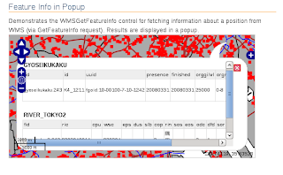
    info = new OpenLayers.Control.WMSGetFeatureInfo({
     url: 'http://localhost:8080/geoserver/wms',
     title: 'Identify features by clicking',
     queryVisible: true,
     eventListeners: {
      getfeatureinfo: function(event) {
       map.addPopup(new OpenLayers.Popup.FramedCloud(
        "chicken",
        map.getLonLatFromPixel(event.xy),
        null,
        event.text,
        null,
        true
       ));
      }
     }
    });
    map.addControl(info);
    info.activate();

    map.addControl(new OpenLayers.Control.LayerSwitcher());
    map.addControl(new OpenLayers.Control.MousePosition()); // 追加
    map.addControl(new OpenLayers.Control.ScaleLine());     // 追加
//  map.zoomToMaxExtent();
    map.zoomToExtent(new OpenLayers.Bounds(-210000,1070000,-200000,1075000));
   }

  </script>
 </head>
 <body onload="load()">
  <h1 id="title">Feature Info in Popup</h1>
  <div id="tags"></div>
  <p id="shortdesc">
   Demonstrates the WMSGetFeatureInfo control for fetching information
   about a position from WMS (via GetFeatureInfo request).  Results
   are displayed in a popup.
  </p>
  <div id="map" class="smallmap"></div>
  <div id="docs"></div>
 </body>
</html>


0 件のコメント:
コメントを投稿